Empower officers in charge with a modern communication and coordination platform. With GINA, they can synchronize response efforts across various units and resolve emergencies effectively.
Trusted by lifesavers
Empowering key industries
Since 2010, GINA’s communication and coordination platform has been a trusted solution for handling emergency situations.
Disaster response units
Police and law enforcement agencies
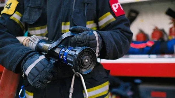
Fire and rescue services
Emergency medical services
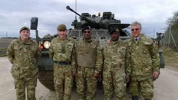
Defense and security forces
Why GINA Software?
50+
Countries
250 K
Users
14Y
History
25+
Partners
Explore our core products
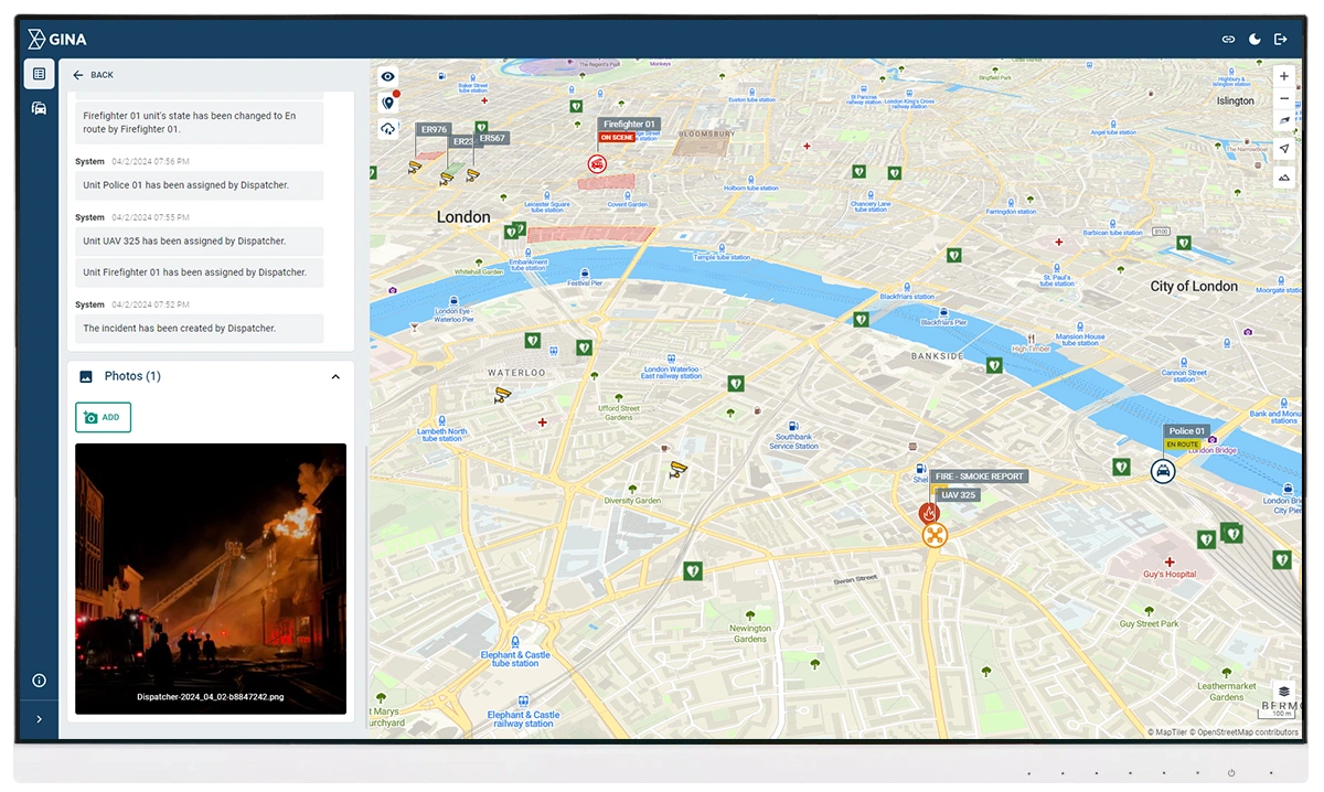
Smart CAD
Smart CAD is easy-to-use software for rapid unit dispatching and incident management, empowering you to increase your operational efficiency.
Tactical AVL is an integrated solution for advanced location tracking, operational intelligence, and swift response that enhances situational awareness.
Partnering with solution providers, such as GINA, who create products that truly answer the needs of people and communities has been pretty amazing. Seeing how technology makes a difference in the real world is why we do what we do. And the results speak for themselves.
Katerina Cipakova
Head of Sales
Sygic
Fire Rescue Service of the Czech Republic
GINA significantly improves the efficiency of both routine and special operations, reduces arrival time, provides real-time information support, and increases the level of cooperation among all responding units. Thanks to technology we can react flexibly to altering situations in the field.
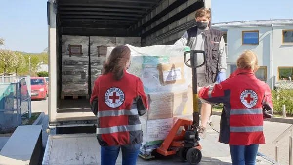
David Jirous
The head of Operational and Information Centre
Fire Rescue Service of the Czech Republic
Czech Red Cross
Many of our members are volunteers who go out from their homes to the scene. At a time like this, it’s great to have an app that lets you see on a map how people are converging on the scene. You can then coordinate much better, for example, by talking to drivers.
Radim Dongres
Deputy commander of the Humanitarian Unit
Czech Red Cross
GM Risk Group
We have been working with GINA for a few years now and have found the software solutions to be a functional tool for our teams on the ground, plus a value add to our clients through our increased service capabilities. GINA provides our team and clients with high-level situational awareness by allowing us to tailor how we integrate, manage and share intelligence that is relevant to our teams and task objectives.
Liam Ryan
CEO
GM Risk Group
Alpha 6 Canada
I was looking for a solution that would handle tracking as well as incident command and I found that in GINA. We can send messages, set up geofences, track our assets and it has good app that goes with it for the smartphone for our clients. GINA provides a lot of things for us. It brings a lot of things together – the tracking, the messaging and then the reporting.
Josh Baquie
Director
Operations at Alpha 6 Tactical Solutions
G2S Group
GINA has been our partner for the past two years in creating and implementing new and tailored systems for our Security company. We are also a business partner for them in the Horn of Africa region as both Facilitator and Reseller for GINA Software in Public Safety, Defense and Security, and Oil and Gas. They are reliable, thorough, smart, available, excellent communicators, and friendly! As a Partner of GINA’s solutions, we’ve obtained a broad positive reception, and allows us to meet the clients’ requirements successfully.
ABDISHAKUR Hassan-kayd
Co-founder
G2S Group
All you need to handle emergencies with confidence
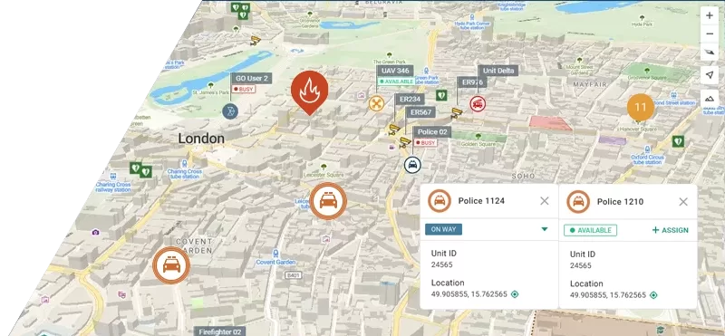
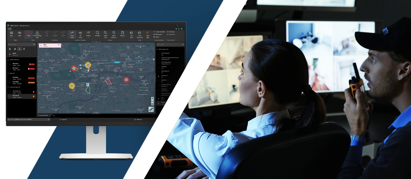
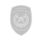
Location tracking
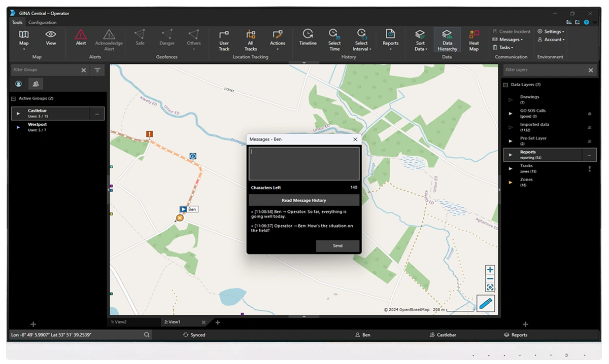
Benefit from real-time location tracking and mapping when coordinating units in the field. GINA supports various monitoring options including radios, trackers, and its own native apps.
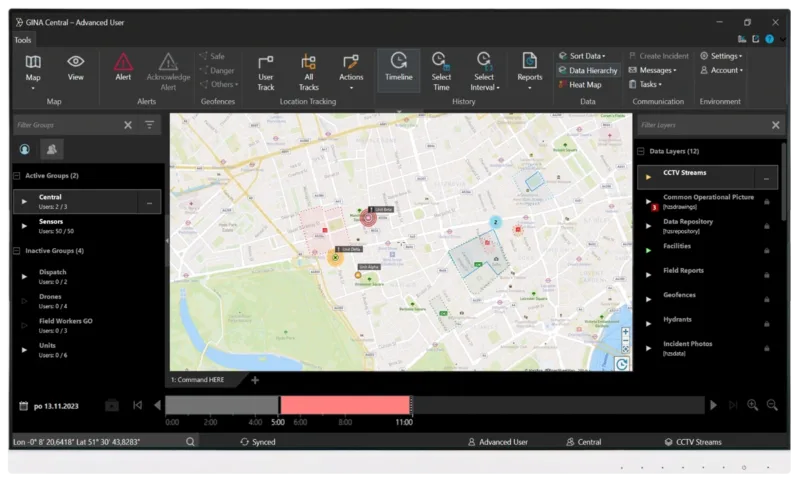
Effective communication
Utilize status updates, multi-media sharing, PTT, and other information exchange options to act fast.GINA serves as a mutual two-way communication platform for both commanders and first-responders.
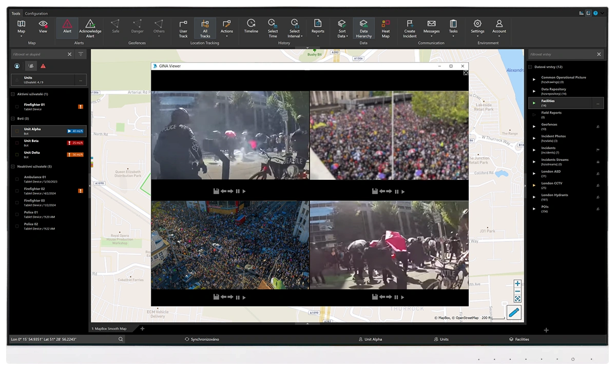
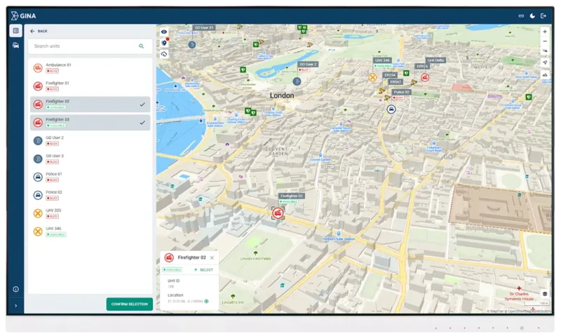
Situational awareness
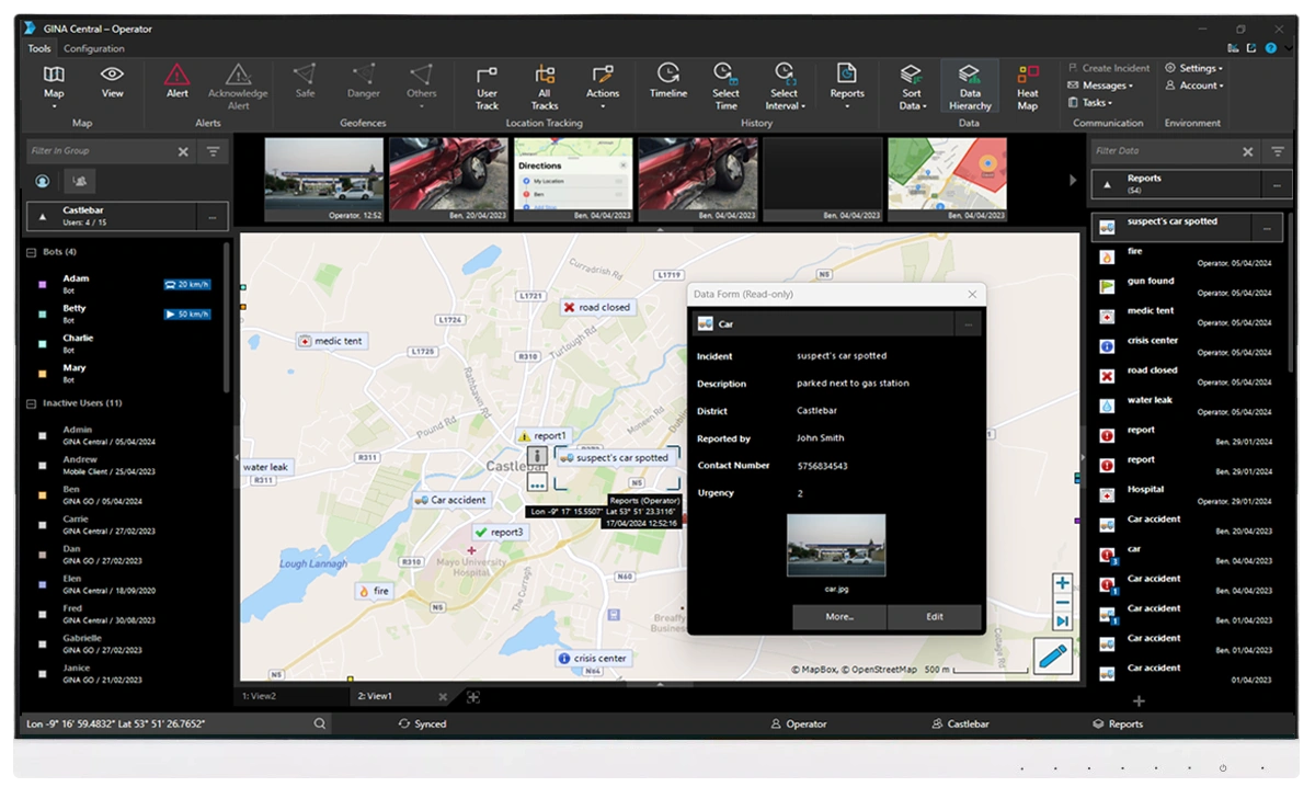
Have a common operating picture to make split-second decisions. GINA consolidates field data, real-time video feeds, specialized databases such as conflict zone information, IoT, and sensor data into one operational dashboard.
Rapid assessment
Collect geolocated field data, including multimedia, in a structured format for analysis, future strategic decision-making, and training.
Data log
Store detailed incident records for future reference and evidence. GINA allows you to store unit movement history, communication logs with timestamps, multimedia, and other operational data.
Affordable
Fast deployment
Trusted partner
Smart solution
FAQ
Emergency response coordination is the process of organizing people, resources, and information so emergencies can be handled quickly and effectively. It ensures that all involved parties, such as central authorities, fire and rescue services, police, EMS and medical teams, emergency dispatchers, civil protection units, and sometimes volunteers, know what to do and work together smoothly.
Strong coordination is essential during situations like large fires, traffic accidents with multiple injuries, floods or storms, hazardous material incidents, and utility outages.
In these moments, having a common operating picture of the situation, clear communication, and a coordinated plan helps teams respond faster, avoid confusion, and protect lives and property.
A real-life example is the coordinated emergency response during major floods, detailed in our case study.
Emergency response coordination relies on a mix of specialized software tools that help teams share information, manage incidents, and respond quickly.
Here is a list of the most widely used emergency-response coordination tools, along with their vendors:
Computer-Aided Dispatch (CAD) systems to handle emergency call information, resource assignment, unit status tracking, and incident logging in real time. Some prominent CAD vendors include GINA, Hexagon, and CentralSquare.
Crisis Incident Management Platforms provide a COP for large incidents, allowing multiple agencies to log incident status, track resources and tasks, share situation reports, and implement the ICS framework in real time. Example: D4H Incident Management.
GIS and mapping tools provide interactive maps, layers, and geospatial data for better decision-making. Example: Esri ArcGIS
Mass Notification Systems such as Everbridge for alerting both the public and emergency personnel.
Interoperable voice and data communication systems to ensure that different responder groups can talk to each other (radio, encrypted team messaging, VoIP, data sharing, push-to-talk apps, live video streaming, etc.).
AVL and tracking systems show the real-time location of vehicles, responders, drones, or other assets on a live map (usually integrated with CAD systems). Example: GINA Tactical AVL.
Field operations apps for mobile phones, tablets, rugged devices, or terminals are used by responders for navigation, checklists, forms, status reporting, and team communication.
An emergency communication system is a combination of software and devices that allows responding units, dispatchers, and commanders to share critical information quickly during emergencies through various channels. These systems are a part of critical infrastructure for situations such as large fires, medical emergencies, industrial accidents, severe weather events, utility outages, evacuations, or civil security threats.
Typically, they support reliable communication between different units such as:
civil protection agencies (public safety organizations, incident command centers),
fire and rescue services,
EMS teams,
law enforcement,
volunteers (e.g., ICRC),
and government or municipal teams.
Emergency communication systems serve as a shared two-way communication platform, supporting radio, real-time navigation, status updates, multimedia sharing, push-to-talk (PTT), and other forms of information exchange.
In short, an emergency communication system ensures that the right information reaches the right people when every second matters.
A real-life example of the importance of an emergency communication system can be seen in our case study from a nationwide public safety organization.
Yes. GINA runs on mobile devices, tablets, and terminals. There are two standalone apps: GINA Mobile and GINA Tablet.
GINA Mobile is a lightweight app designed for users who work in the field, such as responders, volunteers, and other operational teams. It enables smooth communication between dispatchers and field units and makes collecting data in the field quick and easy.
The app works on standard smartphones, LTE and PoC terminals, and rugged mobile devices. It uses 5G/4G/3G/2G or Wi-Fi networks to send real-time location and status updates.
GINA Tablet is a full-featured navigation and tactical system optimized for larger screens. It offers map visualization, routing, and situational tools, making it ideal for vehicles and mobile data terminals.
The GINA Tablet app can operate entirely offline and automatically syncs with the Smart CAD dispatch system once connectivity is restored.
For more details about GINA’s mobile apps, visit the dedicated page.
We want to be transparent and let you explore our solutions in the way that suits you best.
Book a demo with an expert – Get a personalized walkthrough of GINA and see how it fits your specific needs. No commitment required.
Try the interactive product tour – Explore the interface and key features in just a few minutes, with no setup needed. Check out the Smart CAD or Tactical AVL interactive demos to get a feel for how GINA works.
Let's get in touch
Interested in knowing more about GINA? We are here to answer your questions. Drop us a line and one of our experts will get back to you.